Comparing methods for introducing blind and visually impaired people to unfamiliar urban environments
M. Angeles Espinosa *, Simon Ungar †, Esperanza Ochaíta *, Mark Blades ‡ and Christopher Spencer ‡.
*Department of Developmental and Educational Psychology,
Faculty of Psychology,
Madrid Autonoma University,
Cantoblanco, Madrid 28049
Spain
† Department of Psychology,
Glasgow Caledonian University,
Glasgow G4 0BA
U.K.
‡ Department of Psychology,
University of Sheffield,
Sheffield S10 2TP
U.K.
Abstract
This paper reports two experiments which compared the effectiveness of different methods for introducing blind and visually impaired people to the spatial layout of urban environments. In Experiment 1, 30 blind and visually impaired adults learned a long and complex route through an area of central Madrid (Spain) either by direct experience or by a combination of direct experience and a tactile map or a combination of direct experience and a verbal description of the area. Performance on measures of practical spatial knowledge and of representational spatial knowledge was significantly better in participants in the tactile map condition. In Experiment 2, participants learned a similar route in an area of Sheffield (Britain) using either just a tactile map of by direct experience. No significant difference was found between the two conditions using the same measures as in Experiment 1.
Introduction and Aims
Orienting oneself in an environment and moving around rapidly, efficiently and independently is a difficult task, which depends upon a series of processes of relatively high cognitive complexity, including the perception, coding, learning and recall of spatial information (Espinosa, 1994; Espinosa y Ochaíta, in press; Ochaíta y Espinosa, 1996). At the same time, both activities require a person to access or recall different kinds of previously acquired environmental knowledge, such as general knowledge about the space, specific strategies for the acquisition, structuring and integration of spatial information and so-called "spatial products" - more or less structured schemas or representations of familiar environments (Liben, 1988). This task is made considerably more complicated in the case of blind and visually impaired people as one of the main problems for these people is knowledge of surrounding space. When people can move and orient themselves in the environment safely and autonomously, they are more likely to have a sense of security and independence, two essential elements for their integration in a complex society. For this reason, the study of the most effective methods for teaching visually impaired people about space is a primary objective both from a practical and theoretical point of view.
Some researchers working with sighted adults have found that learning about space is highly related to the instructional method used (Hirtle and Hudson, 1991). For example, when people learn a space using a map or a panoramic verbal description, the resulting spatial schemas are better co-ordinated than when the space is learned through direct interaction with the environment or from a sequential verbal description (Thorndyke and Hayes-Roth, 1982). In previous research with blind and visually impaired people we have shown that tactile maps can be a useful means of providing them with complex spatial information about the environment (Ungar, Blades and Spencer, 1993; 1995; 1996a; 1996b).
In previous studies (Espinosa, 1994; Ochaíta and Huertas, 1993; Ochaíta, Huertas and Espinosa, 1991) we have shown that a person's spatial knowledge depends on various factors: factors related to personal characteristics (age, cognitive development, perceptual modality used for coding spatial information), factors related to the characteristics of the environment (size, structure, familiarity, etc.) and factors related to learning processes (strategies for knowledge acquisition, learning conditions, medium for communication of spatial information). We felt it important to study the effect of different instructional methods for teaching visually impaired people about space, while also taking into account the nature of uptake of spatial information through the remaining perceptual systems of visually impaired people (Hollyfield and Foulke, 1983).
Several authors (e.g. Passini and Proulx, 1988; Spencer, Blades and Morsley, 1989) have pointed out that visually impaired people can make use of certain perceptual cues (auditory, tactile, etc.) to acquire, code, store and recover spatial information. Using these alternative strategies, visually impaired people can move and gain efficient knowledge of space. For this reason we can assert that visually impaired people can organize spatial information in a functionally equivalent way to sighted people. However, given the characteristics of perceptual systems other than vision, this task requires more time (Rieser, Guth and Hill, 1986) and more cognitive effort (Byrne and Salter, 1983) than the same task would for sighted people. When we consider different instructional methods, we need to determine what is the most adequate procedure given the capacities of visually impaired people and which methods minimize their time and effort when learning spatial layouts of an unknown environment.
The specific purpose of the present studies was to analyse the effect of different instructional methods on knowledge of a real, unfamiliar and complex space (specifically: direct experience, using a tactile map and learning from a verbal description) in a group of blind and visually impaired people.
To this end, we designed Experiment 1 in which using a tactile map and learning a route via a verbal description were combined with direct experience. From the results of the experiment we decided to compare, in Experiment 2, the effectiveness of each of the methods which had been more successful in Experiment 1 - direct experience and tactile map - when applied separately.
Experiment 1
Participants
The participants were 30 visually impaired adults who were blind from before six years of age. The age of the participants was from 22 to 40 years of age, with an average age of 29 years 3 months. None of the participants had any remaining vision that could be effectively used during the experiment. The experimental group was selected from the total population of adults attending the Mobility and Orientation Centre, of the Spanish Organization for the Blind in Madrid, who had no associated physical and psychological problems. All of them had received orientation and mobility training, and so could move in space independently and efficiently. Thus, they were included on the basis of availability. Each of the participants was randomly assigned to one of the three experimental conditions.
Procedure
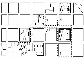
The participants were required to learn a real, unknown, long (2.05 Km) and complex route in an urban environment in a central district of Madrid (Spain) over four sessions in two consecutive days. Therefore, the participants received two learning sessions on the same day with a period of one hour between them. The route included eight landmarks, all of which were important points of reference in the district (See the route and the explanation in Figure 1). All of the landmarks could be recognized by kinaesthetic, auditory, tactile or olfactory cues. There were kinaesthetic cues when the landmark was situated at the top of a slope, on a curve, or on some stairs (landmarks 3, 4, 6 and 7). Auditory cues were given by traffic changes or by other changes from the environment, such as people, children, pigeons, etc.. (landmarks 1, 2, 3, 4, 5, 6, 7 and 8). Tactile cues were given by the different textures of the ground, or when the participant came into contact with some point of reference (landmarks 2, 3, 5, 6, 7 and 8). There were also olfactory cues when the landmark was situated in a garden (landmarks 2, 5 and 7).
Before the training sessions began, the experimenter informed the participants that she would guide them along the route during the first session, but that in the subsequent three sessions they would have to guide her. The participant always walked holding the instructor's arm to feel secure. There were three different methods of instruction.
Direct experience condition: the participant had to walk freely along the route. The instructor guided him or her through the entire route, but without giving any additional information about the environment. Only when the participant arrived at each of the eight landmarks did the instructor gave him or her the name of the landmark of the route. This condition was similar to the traditional method of instruction used by most Orientation and Mobility professionals.
Tactile map condition: the participants carried a tactile map of the route which they could study whenever necessary while they walked along the route. The map was made by a skilled teacher of orientation and mobility from the Spanish Organization for the Blind (O.N.C.E). The map represented, on a sheet of thermoform (25 x 30 cm), the area in which the route was traced. The streets were raised up and labelled with a number. The route was represented by a dotted line and the landmarks were represented by different letters. We also gave the participant two sheets of thermoform, one of them had the name of the landmarks and their corresponding letter written in Braille, the other included the name of the streets and their corresponding number. The map was placed on a rigid surface to allow the participants to read it more easily.
Verbal description condition: in this instructional condition, as in the previous one, the participants had more information than in the direct experience condition, because while they were walking through the route, the instructor described it verbally. The verbal description was sequential: when the participants arrived at each landmark, the characteristics of the route between this landmark and the next was described. Spatial and temporal references were included in this description (see example in Appendix 1).
The participants only received these instructional methods during the first session. In the others, the participants did not receive any additional information. At the end of the first session the participants were then guided by the experimenter to the start of the route along an alternative path. Once there, the experimenter told them that they must retrace the same route which she had taught them previously.
The participants' behaviour was video recorded in all sessions. The information from these recordings was combined with behavioural maps which were traced by the instructor as she accompanied the participants. The behavioural maps were records of the participants' actions and spatial behaviour. The experimenter drew, on a map of the route, exactly the way that the participant was walking in the real environment.
During sessions 2 and 4 the participants were asked to make direction estimates from points 4 and 8 of the route to all the other points of the route. At the end of both sessions the participants were asked to determine what we called a "test shortcut". This task consisted of finding an alternative route to the taught one, that also must be as short as possible, to connect three of the eight points of the route. The test shortcuts were filmed on video and traced on a behavioural map for later analysis, as in the learning sessions. The procedure is summarised in Table 1.
Measures
Measures of practical spatial knowledge
The video recordings and behavioural maps were analysed using two different measures of practical spatial knowledge, which had proved effective in previous studies by our research team (Espinosa, 1994; Huertas and Ochaíta, 1992; Ochaíta, Huertas and Espinosa, 1991).
"Metres off route": the distance in metres which the participant walked off the route. The actual distance which the participant walked off the taught route (2.05 Km) was calculated by applying the appropriate scale transformation to measurements taken from the maps of the participants routes in every session. The off-route distance was measured in millimetres on the map and was converted to a real world distance in metres by applying a ratio of 1:500.
"Deviations from route": the number of times the participant lost their way. We considered a deviation when the participant did not know the correct way to get to the next landmark. When the participant got lost, the experimenter allowed him/her to walk to the next intersection between streets. Then, we asked him or her the right way to reach the next landmark. If the participant knew the correct direction, he/she was allowed to continue along the route, otherwise he/she was guided by the instructor to the next point of the route.
Measures of representational spatial knowledge
Representational or symbolic knowledge was analysed using two different methods which had also been used in previous studies (e.g. Espinosa, Ochaíta, Huertas and Cantalejo, 1933).
"Direction estimates": calculated by finding the difference in degrees between each of the direction estimates made by participants during the fourth session and the true direction of the target.
"Quality of short cut": a score of four was given if the optimal short-cut was chosen, a score of two for correct but sub-optimal route and a score of zero for an incorrect route. The measures used are summarised in Table 2.
Table 2
Measurements taken in each session in Experiment 1.
1 = Metres walked off the taught route;
2 = Number of deviations from the taught route
3 = Direction estimates
4 = Quality of short-cut.
|
Session |
Measurement |
|
Learning session |
- |
|
Session 2 |
1, 2, 3, 4 |
|
Session 3 |
1, 2 |
|
Session 4 |
1, 2, 3, 4 |
Results
An Analysis of Variance (ANOVA) was carried out on the data from the fourth session to determine the effect of the instructional conditions on the practical and representational spatial knowledge of our participants. The results showed a significant effect of the different conditions on practical and representational spatial knowledge (see Table 3) which was observed on all measurements used in this study (p< 0.05). Tukey multiple comparison tests revealed that the participants who learnt the route by using a tactile map walked fewer metres off the route and deviated from the route fewer times than did the other two groups. Similar results were found on representational spatial knowledge; the participants who learnt the route using a tactile map had smaller error scores on direction estimates and higher quality short-cuts than the other two groups.
The results of this experiment show that participants who learned the route from a combination of direct experience of the environment and a tactile map of the area, attained better knowledge of that environment (both practical and representational) than those participants who received only direct experience or a combination of direct experience and a verbal description of the route.
Since the effect using a tactile map was so strong on all the measures of spatial knowledge, we carried out Experiment 2 to determine whether the use of a tactile map on its own (i.e. learning a route from a tactile map before having any direct experience of the environment) would have as strong a facilitatory effect on spatial knowledge when compared with direct experience on its own. Experiment 2 aimed to replicate the direct experience condition of Experiment 1 and compare it with a new condition in which the participants learned a route from a tactile map before walking the route.
Experiment 2
Participants
Ten blind and visually impaired adults took part in the study. The age of the participants was from 20 to 47 years of age, with an average age of 31 years 5 months. Six participants were totally blind and five had some residual vision. None of the participants had any remaining vision that could be effectively used during the experiment. Seven participants were blind from birth or before seven years of age and the rest were later blinded. Five of the participants used a long cane, four had a guide dog and one participant used no aid at all.
Procedure
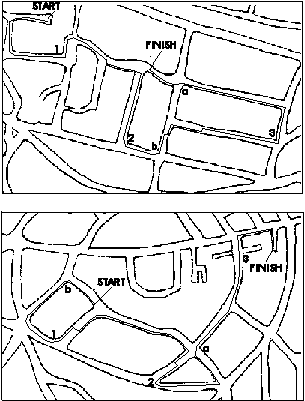
All participants learned two similar routes (both were 1.2 km in length and had 13 decision points) in one area of Sheffield (Britain) (see Figure 2) by one of two instructional methods: direct experience or tactile map. All participants learned both routes, but a different instructional method was used for each. Order of presentation of routes and instructional method were balanced across participants.
Tactile maps of the areas were constructed using the microcapsule process at a scale of approximately 1:3000. The maps represented the road layout using single, 3-point lines to represent roads and showed some landmarks which would be relevant to a blind or partially sighted traveller - grass verges, tree-lined pavements, and roundabouts.
We will describe the instructional methods used in this experiment because although we use the same terms as in Experiment 1, there were important differences with respect to the quantity and quality of information that was given about the space.
In the direct experience condition, participants walked freely along the route, using whatever mobility aid they were accustomed to, while the experimenter walked along side giving directions both shortly before and at each decision point. In contrast to the procedure in Experiment 1, the experimenter also answered any questions the participant had about the route. After this learning session, participants were guided by the experimenter to the start of the route by an alternative path (i.e. they did not take the direct route back to the start, nor retrace the route).
In the tactile map condition, the participant was handed a tactile map at the start of the route and was asked to explore it until they had a reasonable impression of the layout. The map symbols were explained to the participant as they were encountered on the map. The experimenter then placed the participant's finger on the start point of the route and moved the participant's finger along the route. This procedure was used, rather than verbally describing the route as the participant scanned the map, to avoid any map-specific uses of directional labels, such as 'right' and 'left', which may have confounded the subsequent wayfinding exercise. This procedure was repeated until the participant could trace the route twice unaided. Order of presentation of the instructional conditions was counterbalanced.
After the learning session, participants were asked to walk the learned route unguided (Test Session 1), while the experimenter followed and noted on a map of the area the exact route taken by the participant. Participants in the tactile map condition carried the map with them during this phase of the experiment. If participants walked off the route during either of the test phases, they were allowed to walk as far as the next road junction, where the experimenter stopped them and led them back to the previous on-route junction. If the participants did not know how to continue from this point, the experimenter told them which way to go. At the end of Test Session 1, participants in the tactile map condition returned the map to the experimenter. Participants were then guided by the experimenter to the start of the route by an alternative way.
During Test Session 2, participants were also stopped at points along the route and asked to make a total of eight direction estimates to other points on the route. Specifically, participants were asked to point to the end of the route from the start, and from points 1, 2 and 3 and they were asked to point to the start of the route from points 1, 2, 3 and from the end of the route (see Figure 2).
After the Test Session 2, participants were led to a point on the route (marked 'a' in Figure 2) and were asked to find a short cut to another point on the route (marked 'b' in Figure 2), i.e. to get from the first point to the second without retracing their steps along the taught route. These latter measures (direction estimates and short cut) provided data on the representational knowledge which the participants had gained of the area, beyond knowledge of the actual taught route. The procedure for the two instructional conditions is summarised in Table 4.
Measures
From the tasks which the participants carried out, we calculated the same measurements that we used in Experiment 1: metres off route and number of deviations from the route as measures of practical spatial knowledge; and direction estimates and quality of short-cut as measures of representational spatial knowledge. The measures used in Experiment 2 are summarised in Table 5.
Table 5
Measurements taken in each session in Experiment 2.
|
Session |
Measurement |
|
Learning session |
- |
|
Test Session 1 |
1, 2 |
|
Test Session 2 |
1, 2, 3, 4 |
Results
Sixteen separate analyses of variance were carried out. For each of the two measures of practical knowledge, one 2 factor (instructional method x trial) ANOVA and three 3 factor (participant characteristic x instructional method x trial) ANOVAs were carried out, where 'participant characteristic' was degree of impairment (totally blind or residual vision), age at onset of impairment (early or late) and mobility aid (long cane or guide dog) respectively in the three analyses. For each of the representational measures, one 1 factor (instructional method) and three 2 factor (participant characteristic x instructional condition) analyses of variance were carried out.
The results of these analyses showed that there were no significant differences on any of the measures of spatial knowledge (practical of representational) in respect of the variables analysed in Experiment 2: instructional condition, degree of impairment, age at onset of impairment and mobility aid used. Table 6 presents the scores of the participants in the two instructional conditions.
Discussion
To clarify the discussion of the results of these studies, we will first describe the results from each experiment separately, and then suggest some conclusions to synthesise both sets of results.
Experiment 1
From the results of Experiment 1, we can conclude that the instructional conditions resulted in clear differences in the practical spatial and representational knowledge of an unknown environment in a group of visually impaired adults.
The participants who used tactile maps as a supplementary aid to direct experience, showed more accurate spatial behaviour and more co-ordinated and integrated spatial schemas than those participants who did not carry a map or who received a verbal description of the route. The results of this experiment are consistent with studies carried out with sighted people in which the authors state that direct experience is a useful method for acquiring spatial knowledge (Lindberg and Gärling, 1983). Over three learning sessions, the participants' spatial behaviour and representation improved between the second and the fourth session. This can be attributed to their interaction with the environment. However, when participants had access to the spatial information on a tactile map, used a supplementary aid to direct experience, this facilitated mobility and orientation in the space.
When the supplementary information consisted of a verbal description of the route, the results were different. Auditory information about the route did not facilitate the spatial knowledge of the participants relative to those who learned the route by direct experience.
Experiment 2
Overall, the participants performed just as well after exploring a tactile map as they did after direct experience in the environment. In session 1, participants who carried a map performed as well as others who had already had direct experience of the entire route. In session 2, the map group (now relying on the memory of the map that they carried in session 1) still performed as well as the direct experience group (who had the benefit of two complete journeys along the route prior to the second trial). These results suggest that tactile maps, with even quite a brief exposure, are an effective means for introducing blind and visually impaired people to the spatial structure of a novel area. The results are surprising, as it has generally been believed that blind people lack the spatial skills to use tactile maps, such as the ability to appreciate the aerial perspective of a map or to apply a scale transformation necessary to relate the map to the real world. However these results with adults confirm those of previous studies in which blind children used tactile maps to navigate successfully in smaller experimental environments (e.g. Ungar, Blades and Spencer, 1996; Ungar, Blades, Spencer & Morsley, 1994).
Comparison of Experiments 1 & 2.
In Experiment 1 the use of the tactile map generated better practical and representational knowledge of the space, while in Experiment 2 there were no differences between the two instructional conditions. However, these apparently contradictory results may easily be explained within a transactional or contextualist theoretical model (Altman, 1992; Altman & Rogoff, 1987; Stokols, 1987). Within this perspective it is not possible to talk of spatial knowledge without taking account of the more general context in which it is produced. The knowledge which an individual has about an environment at a particular moment depends on many factors relating to the individual, the space itself, the learning task itself, and the culture or micro-culture in which this knowledge is situated, as well as the complex transactions that take place between all these factors.
The Map conditions of Experiment 1 and Experiment 2 were quantitatively and qualitatively different. Although they were labelled the same in both cases, the type of information that they provided to the participants was different. In the map condition of Experiment 1, the participants carried the map with them while they walked the route, and they could consult it as often as they thought necessary, whereas in Experiment 2 they had to learn the map before entering the real space. Learning a route on a map, in this case a tactile one, in order to subsequently move about in a real environment is a complex task which requires memorizing a large amount of information. But at the same time, this task implies a series of high level abilities for blind people such as understanding the scale of the map and extrapolating a series of two dimensional relationships learned from the map to a three dimensional space. So, if in Experiment 2 the map condition required the deployment of a series of abilities which were complex for the blind participants (which made spatial learning much more difficult compared with the way the map was used in Experiment 1), one would expect less difference between instructional conditions in Experiment 2.
The number of training sessions that the participants received in both experiments was different. If, as we have argued in other parts of this paper, spatial knowledge which a person has of an environment at a particular time depends on the complex transactions in engagement with that environment, then the quantity of exchanges that the person has with the environment must necessarily determine any differences with respect to the knowledge that he or she has about the environment. The more opportunities a person has to interact with an environment, the more chances there will be to organize the spatial information acquired from that environment (because spatial schemas are modified and produced each time they are used and recalled) and that the information will be recalled efficiently on occasions when it is needed. In this way, the participants in Experiment 1 who received a greater number of training sessions, had more chance of showing differences between the different instructional conditions. Closely related to this argument is the idea that the participants learned from the tasks that they had to perform during each of the training sessions. Again, we note that while the participants in Experiment 1 had to estimate directions and find a shortcut in the second and fourth sessions, the participants in Experiment 2 only performed these tasks in the second session.
The usefulness of tactile maps for teaching visually impaired people (from an early age) about space, has been demonstrated in several studies (Ungar, Blades and Spencer, 1993). In Experiment 1 the use of a tactile map resulted in increased configurational knowledge of the environment, relative to direct experience. Analysis of the representational measures of Experiment 2 (direction estimates and of scores on the short-cut exercise) gave no evidence of such an advantage. It seems likely from this, that the participants in Experiment 2 used the tactile map purely as a means of following the route, and ignored the overall layout. It is possible that longer exposure to the map, perhaps with the addition of explicit instructions to attend to the overall layout, might have resulted in an advantage of the map on the representational measures. As we argued earlier, such survey knowledge would support freer and more flexible wayfinding.
Although no facilitatory effect of using a map was found in Experiment 2, there are important practical consequences of the fact performance in the two experimental conditions did not differ significantly for any of the measures of spatial knowledge. This suggests that a tactile map can be at least as effective as direct experience for gaining spatial knowledge of an urban environment. Compared to the conventional method of direct familiarization with an area, which is very time-consuming, a map can be studied before going to the area. It is also possible for a visually impaired person to use a tactile map to familiarize themselves with an area, thus potentially reducing their dependence on carers.
Conclusion
We argue that the combination of two procedures (direct experience and tactile maps) constitutes a useful procedure which should be used by orientation and mobility instructors. The joint use of the two procedures may overcome any limitations of each method used in isolation. For this reason we would stress the value of using a procedure which combines both methods. However, in situations where it is impractical or impossible to provide guided direct experience, then even a tactile map used in isolation can be an adequate means of familiarizing oneself with an environment.
ACKNOWLEDGEMENTS: The research reported here was funded by the Dirección General de Investigación Científica y Técnica (DGCYT) of the Spanish Governent and by the Economic and Social Research Council (ESRC) of the U.K. The authors wish to thank the Spanish Organization for the Blind (ONCE) for it's collaboration, as well as all our participants in Mardid and in Sheffield.
Appendix
Example of verbal description: Route between landmarks 1 and 2.
(We are standing on the corner of Castelló and Padilla streets. This is the first landmark of the route).
"I am going to show you a district of Madrid, the district of Salamanca. As you probably know, this area has an important commercial, social and cultural life. The route that you have to learn is composed by eight landmarks situated in eight important places for the daily life of this district. Now, I am going to describe you each one of the landmarks or places that you have to reach, and also the instructions that you need for learn the route that links these landmarks.
"We are standing at the first landmark of the route, Juan March Foundation. It is a modern building situated on the corner of Castelló and Padilla streets. Many exhibitions of painting and sculpture are shown in this building...." "Castello and Padilla streets are both one-way streets...".
(We continue walking, and we arrive at the traffic light).
"Now we cross Castelló street and we continue walking on the right pavement.."
(We arrive at the corner between Pricipe de Vergara y Padilla streets).
"Now we turn to the left, we cross Padilla street and we continue walking on Principe de Vergara. This is a very broad, two-way street.."
"We have arrived at Nuestra Señora del Rosario Hospital, the second landmark of the route. This hospital is surrounded by a fence and it has a nice garden..."
References
Altman, I. (1992). A transactional perspective on transitions to new environments. Environment and Behaviour, 24 (2), 268-280.
Altman, I. and Rogoff, B. (1987). World views in psychology: Trait, interactional, organismic and transactional perspectives. In D. Stokols and I. Altman (Eds.), Handbook of environmental psychology. New York Wiley.
Byrne, R.W. and Salter, E. (1983). Distances and directions in the cognitive maps of the blind, Canadian Journal of Psychology, 37, 293-299.
Espinosa, M.A. (1994). Un estudio transaccional sobre la ciudad de Madrid y dos de sus barrios (A transactional study about Madrid city and two of its suburbs). Unpublished Ph.D. thesis. Universidad Autónoma de Madrid.
Espinosa, M.A. and Ochaíta, E. (in press). Tactile maps: A useful instructional method for improving the practical spatial knowledge of visually impaired people. Journal of Visual Impairment and Blindness.
Espinosa, M.A., Ochaíta, E., Huertas, J.A. and Cantalejo, J.J. (1993).Three different methods of instruction for spatial learning in blind and sighted people. Paper presented at the 5th European Conference on Research on Learning and Instruction, Aix en Provence, France, 31 August to 5 September.
Hirtle, S.C. and Hudson, J. (1992). Acquisition of spatial knowledge for routes. Journal of Environmental Psychology, 11 (4), 335-347.
Huertas, J.A. and Ochaíta, E. (1992). The externalization of spatial representation by blind persons. Journal of Visual Impairment and Blindness, 86, 398-402.
Hollyfield, R.L. and Foulke, E. (1983). The spatial cognition of blind pedestrians, Journal of Visual Impairment and Blindness, May, 205-210.
Liben, L.S.
(1988). Conceptual issues in the development of spatial cognition. In Stiles-Davis, J., Kritchevsky, M. & Bellugi, V. (ed) Spatial Cognition: Brain Bases and Development. Hillsdale, New Jersey: Lawrence Erlbaum Associates.Lindberg, E. and Gärling, T. (1983). Acquisition of locational information in cognitive maps: automatic effortful processing?. Psychological Research, 45, 19-38.
Ochaíta, E. and Espinosa, M.A. (1996). Conducta y representación: ¿Dos formas diferentes de conocer el espacio? (Behaviour and representation: Two different forms of spatial knowledge?). In Monografies Psico-Socio Ambientals, (pp. 267-273). Barcelona: Universitat de Barcelona.
Ochaíta, E. and Huertas, J.A. (1993). Spatial representation by persons who are blind: A study of the effects of learning and development. Journal of Visual Impairment and Blindness, 87, 37-41.
Ochaíta, E., Huertas, J.A. and Espinosa, M.A. (1991). Representación espacial en los niños ciegos: una investigación sobre las principales variables que la determinan y los procedimientos de objetivación más adecuado (Spatial representation in blind children: An investigation into the main determining factors and the most appropriate externalization techniques). Infancia and Aprendizaje, 54, 53-79.
Passini, R. and Proulx, G. (1988). Wayfinding without vision: An experiment with congenitally totally blind people. Environment and Behaviour, 20, 227-252.
Rieser, J.J., Guth, D.A. & Hill, E.W. (1986). Sensitivity to perspective structure while walking without vision. Perception, 15, 173-188.
Spencer, C., Blades, M. and Morsley, K. (1989). The child in the physical environment: The development of spatial knowledge and cognition, Chichester, Wiley.
Stokols, D. (1987). Scientific and policy challenges of a contextually-oriented psychology. In D. Stokols and I. Altman (Eds.), Handbook of environmental psychology. New York: Wiley.
Thorndyke, P.W. and Hayes-Roth, B. (1982). Differences in spatial knowledge acquired from maps and navigation. Cognitive Psychology, 14, 560-589.
Ungar, S., Blades, M. and Spencer, C. (1993). The role of tactile maps in mobility training. The British Journal of Visual Impairment, 11, 59-61.
Ungar, S., Blades, M. and Spencer, C. (1995). Visually impaired children's strategies for memorising a map. British Journal of Visual Impairment, 13, 27-32.
Ungar, S., Blades, M. & Spencer, C. (1996a). The ability of visually impaired children to locate themselves on a tactile map. Journal of Visual Impairment and Blindness, 90, 526-535.
Ungar, S., Blades, M and Spencer, C. (1996b). The construction of cognitive maps by children with visual impairments. In Portugali, J. (Ed.), The Construction of Cognitive Maps. Dordrecht: Kluwer Academic Publishers.
Ungar, S., Blades, M., Spencer, C. & Morsley, K. (1994). Can visually impaired children use tactile maps to estimate directions. Journal of Visual Impairment & Blindness, 88, 221-233.