The post The Portuslimen Project. Geophysical Survey and Boreholes at Pozzuoli, the Bay of Naples appeared first on Shipwrecks and Submerged Worlds.
]]>
The Bay of Naples looking from the Campi Flegrei towards Miseno and Ischia.
In other parts of the town, archaeological remains are visible, including the amphitheatre and the amazing so-called Serapide, and these sites, together with the mapping of submerged structures, provides a broad layout of the ancient port. The objective of the Portuslimen, however, is to map the extent of buried archaeological remains along the edge of the modern shoreline, to better understand the layout of the port. These results can then be combined with the borehole data also collected by the project. The survey marks a collaboration with the archaeologists of Pozzuoli, led by Dott.ssa Costanza Gialanella of the Soprintendenza per i Beni Archeologici di Napoli, and provides an unparalleled opportunity to use non-intrusive methods at the site.
In order to carry out the work, a team of surveyors travelled from the University of Southampton to undertake the survey. The team consisted of Diana Blumberg, Steve Guy-Gibbens, Tyra Standen and Peter Wheeler. In addition Nicolas Carayon and Ferreol Salomon of the Portuslimen team travelled out to supervise the borehole survey.

The so-called Serapide at the marina of Pozzuoli
In terms of geophysical survey techniques, the particular methods presented an issue. Some of the survey areas presented volcanic sands, laden with magnetite, and others were formed from asphalt and cement with iron rebars, train lines, and other iron infrastructure. These all presented difficulties for magnetometry with our fluxgate gradiometer. In addition the insulating properties of the asphalt made Electrical Resistivity Tomography (ERT) impossible (although with luck we may have results of some collaborative work using this technique to report on in the near future). This meant that the survey team had recourse to GPR. Fortunately the satellite coverage for the survey area was strong, and gridding out for the survey could be conducted using an RTK GPS.

Setting up the RTK GPS

Some of the iron infrastructure that made the survey difficult
The GPR survey was conducted using a Sensors and Software 500MHz antenna with Smartcart and odometer. The survey profiles were collected along 0.5m traverses, with traces of data collected at 0.05m intervals. The start and end locations of each traverse were recorded in the local grid coordinate system in a notebook, for entering into the software each evening with the data.

GPR and note-taking on site

Lines in the sand – Peter Wheeler surveys the foreshore at Arco Felice
The GPR collected data across the areas of modern cement and industrial areas, but also across the beach at Arco Felice. The data were complemented by a series of boreholes conducted by Ferreol and Nicolas. The data from these will not only allow comparison between the sediments in the cores and the GPR, but will facilitate dating of material, and potentially develop our interpretations of the volcanic materials and archaeology of the port.
Processing of the results is ongoing, but hopefully this gives a flavour of the issues and problems encountered during the survey, and the methodological process applied at the site.

![]()
The post The Portuslimen Project. Geophysical Survey and Boreholes at Pozzuoli, the Bay of Naples appeared first on Shipwrecks and Submerged Worlds.
]]>
So another season of survey and augering is under way at Thebes. The Theban Harbours and Waterscapes Survey has, for the past 5 years, been using geoarchaeological and geophysical survey to study the changing floodplain of the river Nile, and … Continue reading →![]()
The post THaWS 2016. A Late Start and Sediments Beyond the Temple of Ay and Horemheb appeared first on Shipwrecks and Submerged Worlds.
]]>
So another season of survey and augering is under way at Thebes. The Theban Harbours and Waterscapes Survey has, for the past 5 years, been using geoarchaeological and geophysical survey to study the changing floodplain of the river Nile, and the dynamics between the ancient harbours and waterways and the Theban temple complexes on the West Bank and Luxor and Karnak temples. In 2015 the survey work focused on the areas around Kom El Hetan and the Ramesseum, with Electrical Resistivity Tomography profiles and auger locations running from the edge of the floodplain to the modern course of the Nile. In addition an area survey was conducted over the mounds at Malqata, associated with the harbour of Birket Habu. This year the season is focussing its attention on the floodplain between the colossal seated statues of Amenhotep III and his huge ceremonial lake (Birket Habu), immediately to the east of the funerary temple of Ay and Horemheb.
Sunrise over the Nile floodplain as viewed from the West Bank
After a slight delay at the start of the project for permits, the work commenced on 19th January. Reconnaissance of the area to the east of the temple, looking for a route across the floodplain for both ERT and auger locations, was conducted last autumn and walked over by the team as we waited for our paperwork to be completed.
The aim of the transect of boreholes (hand augering and a percussion coring) and geophysical survey (Electrical Resistivity Tomography (ERT)) is to understand the geoarchaeological history of the floodplain in this area of Thebes. We are using our RTK GPS to establish the location of the ERT profiles and to survey in borehole locations during the course of the work.
Carolin Johansson (Medelhavsmuseet, Stockholm) setting up the GPS base station
Carolin conducting GPS survey along an ERT traverse
As the ERT survey was set up and continued to collect data across the floodplain from west to east, the team also attempted some GPR. However, issues with the equipment meant that no survey could be completed, and this will have to wait until later in the season. The augering got off to a flying start, with boreholes starting immediately east of the temple of Ay and Horemheb and supported by the ERT profile data. The coring and hand augering both revealed the variation in the sediments from the desert edge, running east across the floodplain, with different depths of silts and sands.
Ben Pennington (University of Southampton) removing sediment from the auger head assisted by Mohammed
Dominic Barker (University of Southampton) gets to grips with a corer sample
Jan Peeters (Utrecht University) recording sediments from Auger site 71 in the West Bank floodplain with the Theban hills in the background and assisted by Moustapha (auger) and Hassan (sitting) and onlooked by Zazou, who is working on the ERT profile behind them
Willem Toonen (Aberystwyth University) working at auger site 67 with Youssef and Ahmed in front of the funerary temple of Ay and Horemheb with Medinet Habu immediately south (in the background)
The work with the augers was matched by the pace of the ERT, with resistivity data being collected along a traverse completed in four separate profiles, measuring over 2.7km in length. This traverse is located to complement the borehole data and the ERT data collected in the traverse to the east of the Ramesseum in 2014 and 2015, allowing comparison of the varying resistivity values from both locations.
Zazou, Ahmed, Reis Alaa and Sumara take a well-earned rest while the ERT collects data
As with many field projects, in some cases the work in the field marks only a part of the overall effort. Once the geophysical survey data is collected, and the auger samples are bagged or put into plastic tubes, the hard work of data processing and study of the augered samples begins. After a week of work, the whole team was called on to soak, sieve and pick through the sediments, weighing and measuring the different inclusions in the sediment to glean as much information about the nature and chronology of the floodplain sediments as possible. This data will be compared with the geophysics to help ground-truth the data and provide crucial information of the potential date of different deposits.
The preliminary data is already pointing to some interesting results on the deposition of sediments deposits, and their relationship with the West Bank monuments. There is still lots of processing and studying to be done!
Bird’s eye view of clasts from sieved samples drying and then being sorted from the borehole sediments
The post THaWS 2016. A Late Start and Sediments Beyond the Temple of Ay and Horemheb appeared first on Shipwrecks and Submerged Worlds.
]]>The post THaWS 2016. A Late Start and Sediments Beyond the Temple of Ay and Horemheb appeared first on Shipwrecks and Submerged Worlds.
]]>

Sunrise over the Nile floodplain as viewed from the West Bank
After a slight delay at the start of the project for permits, the work commenced on 19th January. Reconnaissance of the area to the east of the temple, looking for a route across the floodplain for both ERT and auger locations, was conducted last autumn and walked over by the team as we waited for our paperwork to be completed.
The aim of the transect of boreholes (hand augering and a percussion coring) and geophysical survey (Electrical Resistivity Tomography (ERT)) is to understand the geoarchaeological history of the floodplain in this area of Thebes. We are using our RTK GPS to establish the location of the ERT profiles and to survey in borehole locations during the course of the work.

Carolin Johansson (Medelhavsmuseet, Stockholm) setting up the GPS base station

Carolin conducting GPS survey along an ERT traverse
As the ERT survey was set up and continued to collect data across the floodplain from west to east, the team also attempted some GPR. However, issues with the equipment meant that no survey could be completed, and this will have to wait until later in the season. The augering got off to a flying start, with boreholes starting immediately east of the temple of Ay and Horemheb and supported by the ERT profile data. The coring and hand augering both revealed the variation in the sediments from the desert edge, running east across the floodplain, with different depths of silts and sands.

Ben Pennington (University of Southampton) removing sediment from the auger head assisted by Mohammed

Dominic Barker (University of Southampton) gets to grips with a corer sample

Jan Peeters (Utrecht University) recording sediments from Auger site 71 in the West Bank floodplain with the Theban hills in the background and assisted by Moustapha (auger) and Hassan (sitting) and onlooked by Zazou, who is working on the ERT profile behind them

Willem Toonen (Aberystwyth University) working at auger site 67 with Youssef and Ahmed in front of the funerary temple of Ay and Horemheb with Medinet Habu immediately south (in the background)
The work with the augers was matched by the pace of the ERT, with resistivity data being collected along a traverse completed in four separate profiles, measuring over 2.7km in length. This traverse is located to complement the borehole data and the ERT data collected in the traverse to the east of the Ramesseum in 2014 and 2015, allowing comparison of the varying resistivity values from both locations.

Zazou, Ahmed, Reis Alaa and Sumara take a well-earned rest while the ERT collects data
As with many field projects, in some cases the work in the field marks only a part of the overall effort. Once the geophysical survey data is collected, and the auger samples are bagged or put into plastic tubes, the hard work of data processing and study of the augered samples begins. After a week of work, the whole team was called on to soak, sieve and pick through the sediments, weighing and measuring the different inclusions in the sediment to glean as much information about the nature and chronology of the floodplain sediments as possible. This data will be compared with the geophysics to help ground-truth the data and provide crucial information of the potential date of different deposits.
The preliminary data is already pointing to some interesting results on the deposition of sediments deposits, and their relationship with the West Bank monuments. There is still lots of processing and studying to be done!

Bird’s eye view of clasts from sieved samples drying and then being sorted from the borehole sediments

![]()
The post THaWS 2016. A Late Start and Sediments Beyond the Temple of Ay and Horemheb appeared first on Shipwrecks and Submerged Worlds.
]]>The post THaWS 2016. A Late Start and Sediments Beyond the Temple of Ay and Horemheb appeared first on Shipwrecks and Submerged Worlds.
]]>
Sunrise over the Nile floodplain as viewed from the West Bank
After a slight delay at the start of the project for permits, the work commenced on 19th January. Reconnaissance of the area to the east of the temple, looking for a route across the floodplain for both ERT and auger locations, was conducted last autumn and walked over by the team as we waited for our paperwork to be completed.
The aim of the transect of boreholes (hand augering and a percussion coring) and geophysical survey (Electrical Resistivity Tomography (ERT)) is to understand the geoarchaeological history of the floodplain in this area of Thebes. We are using our RTK GPS to establish the location of the ERT profiles and to survey in borehole locations during the course of the work.
Carolin Johansson (Medelhavsmuseet, Stockholm) setting up the GPS base station
Carolin conducting GPS survey along an ERT traverse
As the ERT survey was set up and continued to collect data across the floodplain from west to east, the team also attempted some GPR. However, issues with the equipment meant that no survey could be completed, and this will have to wait until later in the season. The augering got off to a flying start, with boreholes starting immediately east of the temple of Ay and Horemheb and supported by the ERT profile data. The coring and hand augering both revealed the variation in the sediments from the desert edge, running east across the floodplain, with different depths of silts and sands.
Ben Pennington (University of Southampton) removing sediment from the auger head assisted by Mohammed
Dominic Barker (University of Southampton) gets to grips with a corer sample
Jan Peeters (Utrecht University) recording sediments from Auger site 71 in the West Bank floodplain with the Theban hills in the background and assisted by Moustapha (auger) and Hassan (sitting) and onlooked by Zazou, who is working on the ERT profile behind them
Willem Toonen (Aberystwyth University) working at auger site 67 with Youssef and Ahmed in front of the funerary temple of Ay and Horemheb with Medinet Habu immediately south (in the background)
The work with the augers was matched by the pace of the ERT, with resistivity data being collected along a traverse completed in four separate profiles, measuring over 2.7km in length. This traverse is located to complement the borehole data and the ERT data collected in the traverse to the east of the Ramesseum in 2014 and 2015, allowing comparison of the varying resistivity values from both locations.
Zazou, Ahmed, Reis Alaa and Sumara take a well-earned rest while the ERT collects data
As with many field projects, in some cases the work in the field marks only a part of the overall effort. Once the geophysical survey data is collected, and the auger samples are bagged or put into plastic tubes, the hard work of data processing and study of the augered samples begins. After a week of work, the whole team was called on to soak, sieve and pick through the sediments, weighing and measuring the different inclusions in the sediment to glean as much information about the nature and chronology of the floodplain sediments as possible. This data will be compared with the geophysics to help ground-truth the data and provide crucial information of the potential date of different deposits.
The preliminary data is already pointing to some interesting results on the deposition of sediments deposits, and their relationship with the West Bank monuments. There is still lots of processing and studying to be done!
Bird’s eye view of clasts from sieved samples drying and then being sorted from the borehole sediments
![]()
The post THaWS 2016. A Late Start and Sediments Beyond the Temple of Ay and Horemheb appeared first on Shipwrecks and Submerged Worlds.
]]>The post The Portuslimen Project. Geophysical Survey and Fieldwalking at Ephesus appeared first on Shipwrecks and Submerged Worlds.
]]>In August and September of 2015 a small team of archaeologists from the University of Southampton travelled to Ephesus in Turkey, to take part in the season of fieldwork run by the Österreichisches Archäologisches Institut (ÖAI). The ÖAI has conducted archaeological research at Ephesus for 120 years (http://www.oeai.at/index.php/grabungsgeschichte.html ), and for the last 16 years has conducted geophysical survey across the site, with work directed by Dr Sirri Seren of the Central Institute for Meteorology and Geodynamics (https://www.zamg.ac.at/cms/en/news). The Portuslimen team were invited to look at some very specific areas of the ancient site and landscape, namely the areas of the inner and outer Roman harbours, and the surrounding landscape of the river. The aim of the survey was to add to the areas already surveyed by the ÖAI, and to address the development and possible phasing of the harbour complexes of ancient Ephesus. The team comprised the author, together with Dominic Barker, Ben Urmston, Jack Pink and Jack Frowde.

Panoramic view of the area of the outer harbour and river as seen from the promontory

Magnetometry being undertaken at the inner harbour
To address these aims the team utilised fluxgate gradiometers, with gridding out and topographic survey conducted using an RTK GPS. Magnetometry was used in a field to the east of the inner harbour of Ephesus, and in fields around the outer harbour and river channel, also on the promontory overlooking the outer harbour.
In addition Electrical Resistivity Tomography (ERT) profiles were conducted at sites along the northern edge of the river channel, across the area of land between the outer harbour and river, and in the area of the floodplain to the north of the inner harbour. These were designed to assess the nature of the deeper sediments associated with the geoarchaeology of the landscape, for comparison with the borehole data collected by the University of Koln.
Although the geophysical survey techniques were deemed appropriate for the conditions of the site, the broad geographical range of the different survey areas,and the potential variations in phasing for the different results, presented the team with a problem; how to recognise the different periods of occupation in these areas, together with an idea of the character and function of many of the structures. To address these issues, fieldwalking was undertaken over each of the survey areas., utilising the grid set out for the geophysics, and using each of the survey markers as the central point for an area of surface material to be collected and recorded within a a 3m radius.

Set out of the survey grid using an RTK GPS

ERT survey to the north of the river channel

Surface collection to the north of the river channel, using the RTK GPS and note-taking
The method of sampling allowed collection of all pottery, with a record of presence and absence of CBM (? meaning )and building material. The collection of surface ceramics provides the diagnostic sherds necessary for establishing the type and chronology of the vessels, while its total collection over a small but standard sample area make it possible to calculate the count and weight of sherds and, thus, the potential ceramic density density in each area.
The results of the survey not only provided some excellent information about structures and port infrastructure in the different areas, but also provided some useful spot-dating of the potential phases of occupation of the areas. On the promontory overlooking the outer harbour a number of pit and gully features were found in the geophysical survey results, matching other surface evidence for Archaic settlement pre-dating the Roman harbour. The results of survey to the north and west of the outer harbour indicated large structures associated with the port, dating to the Roman and Late Antique periods. Finally the survey results to the north of the modern river channel detected structures and a possible canal that, when compared to the surface collection, seem to represent Late Roman and Byzantine phases of the port of Ephesus.

Location of surface collection points across the 2015 survey area

Roman amphora bases located to the west of the outer harbour
The results of the season are only preliminary, and further work needs to be undertaken on the data and at the site to fully understand the complexities of the changing harbours of Ephesus. However, a pattern is emerging which seems to indicate a gradual shift in the development of port infrastructure, with activity moving from the inner and outer harbours between the early Roman and Late Antique periods, to a later complex to the north of the modern river between the Late Antique and Byzantine periods. The evidence for pre-Roman occupation in the area is also of interest.
There are obvious caveats about the methodology that we have applied to the site, such as the depth of potential deposits and the nature of material exposed at the surface, which will ultimately affect the dating of material to particular periods of occupation. However, the combined strategy of surface collection and geophysical survey does provide us with a more nuanced data-set than with geophysics on their own, and has already started to raise interesting questions relating to the development and use of this fascinating port complex.

![]()
The post The Portuslimen Project. Geophysical Survey and Fieldwalking at Ephesus appeared first on Shipwrecks and Submerged Worlds.
]]>The post The Portuslimen Project. Geophysical Survey and Fieldwalking at Ephesus appeared first on Shipwrecks and Submerged Worlds.
]]>In August and September of 2015 a small team of archaeologists from the University of Southampton travelled to Ephesus in Turkey, to take part in the season of fieldwork run by the Österreichisches Archäologisches Institut (ÖAI). The ÖAI has conducted archaeological research at Ephesus for 120 years (http://www.oeai.at/index.php/grabungsgeschichte.html ), and for the last 16 years has conducted geophysical survey across the site, with work directed by Dr Sirri Seren of the Central Institute for Meteorology and Geodynamics (https://www.zamg.ac.at/cms/en/news). The Portuslimen team were invited to look at some very specific areas of the ancient site and landscape, namely the areas of the inner and outer Roman harbours, and the surrounding landscape of the river. The aim of the survey was to add to the areas already surveyed by the ÖAI, and to address the development and possible phasing of the harbour complexes of ancient Ephesus. The team comprised the author, together with Dominic Barker, Ben Urmston, Jack Pink and Jack Frowde.
Panoramic view of the area of the outer harbour and river as seen from the promontory
Magnetometry being undertaken at the inner harbour
To address these aims the team utilised fluxgate gradiometers, with gridding out and topographic survey conducted using an RTK GPS. Magnetometry was used in a field to the east of the inner harbour of Ephesus, and in fields around the outer harbour and river channel, also on the promontory overlooking the outer harbour.
In addition Electrical Resistivity Tomography (ERT) profiles were conducted at sites along the northern edge of the river channel, across the area of land between the outer harbour and river, and in the area of the floodplain to the north of the inner harbour. These were designed to assess the nature of the deeper sediments associated with the geoarchaeology of the landscape, for comparison with the borehole data collected by the University of Koln.
Although the geophysical survey techniques were deemed appropriate for the conditions of the site, the broad geographical range of the different survey areas,and the potential variations in phasing for the different results, presented the team with a problem; how to recognise the different periods of occupation in these areas, together with an idea of the character and function of many of the structures. To address these issues, fieldwalking was undertaken over each of the survey areas., utilising the grid set out for the geophysics, and using each of the survey markers as the central point for an area of surface material to be collected and recorded within a a 3m radius.
Set out of the survey grid using an RTK GPS
ERT survey to the north of the river channel
Surface collection to the north of the river channel, using the RTK GPS and note-taking
The method of sampling allowed collection of all pottery, with a record of presence and absence of CBM (? meaning )and building material. The collection of surface ceramics provides the diagnostic sherds necessary for establishing the type and chronology of the vessels, while its total collection over a small but standard sample area make it possible to calculate the count and weight of sherds and, thus, the potential ceramic density density in each area.
The results of the survey not only provided some excellent information about structures and port infrastructure in the different areas, but also provided some useful spot-dating of the potential phases of occupation of the areas. On the promontory overlooking the outer harbour a number of pit and gully features were found in the geophysical survey results, matching other surface evidence for Archaic settlement pre-dating the Roman harbour. The results of survey to the north and west of the outer harbour indicated large structures associated with the port, dating to the Roman and Late Antique periods. Finally the survey results to the north of the modern river channel detected structures and a possible canal that, when compared to the surface collection, seem to represent Late Roman and Byzantine phases of the port of Ephesus.
Location of surface collection points across the 2015 survey area
Roman amphora bases located to the west of the outer harbour
The results of the season are only preliminary, and further work needs to be undertaken on the data and at the site to fully understand the complexities of the changing harbours of Ephesus. However, a pattern is emerging which seems to indicate a gradual shift in the development of port infrastructure, with activity moving from the inner and outer harbours between the early Roman and Late Antique periods, to a later complex to the north of the modern river between the Late Antique and Byzantine periods. The evidence for pre-Roman occupation in the area is also of interest.
There are obvious caveats about the methodology that we have applied to the site, such as the depth of potential deposits and the nature of material exposed at the surface, which will ultimately affect the dating of material to particular periods of occupation. However, the combined strategy of surface collection and geophysical survey does provide us with a more nuanced data-set than with geophysics on their own, and has already started to raise interesting questions relating to the development and use of this fascinating port complex.
![]()
The post The Portuslimen Project. Geophysical Survey and Fieldwalking at Ephesus appeared first on Shipwrecks and Submerged Worlds.
]]>
One of the more constraining factors of geophysical survey in an archaeological context is the potential difficulty in dating or phasing anomalies in the data. Although hard science forms the main component of survey work, there is a large subjective … Continue reading →![]()
The post The Portuslimen Project. Geophysical Survey and Fieldwalking at Ephesus appeared first on Shipwrecks and Submerged Worlds.
]]>
One of the more constraining factors of geophysical survey in an archaeological context is the potential difficulty in dating or phasing anomalies in the data. Although hard science forms the main component of survey work, there is a large subjective element involved in the interpretation of geophysical survey data, which ultimately can decide the nature, function and phase of features. Our interpretation sometimes belies the complexity of the archaeological remains in question (issues relating to survey resolution and the nature of deposits can affect this) and this is particularly true of the different phases of construction and occupation at a site. Complementary information on the phases of deposits represented in geophysical survey data can be provided through surface collection and recording over the survey area, and this integrated approach to archaeological survey is particularly pertinent to the recent Portuslimen survey conducted at Ephesus.
In August and September of 2015 a small team of archaeologists from the University of Southampton travelled to Ephesus in Turkey, to take part in the season of fieldwork run by the Österreichisches Archäologisches Institut (ÖAI). The ÖAI has conducted archaeological research at Ephesus for 120 years ( ), and for the last 16 years has conducted geophysical survey across the site, with work directed by Dr Sirri Seren of the Central Institute for Meteorology and Geodynamics ( The Portuslimen team were invited to look at some very specific areas of the ancient site and landscape, namely the areas of the inner and outer Roman harbours, and the surrounding landscape of the river. The aim of the survey was to add to the areas already surveyed by the ÖAI, and to address the development and possible phasing of the harbour complexes of ancient Ephesus. The team comprised the author, together with Dominic Barker, Ben Urmston, Jack Pink and Jack Frowde.
Panoramic view of the area of the outer harbour and river as seen from the promontory
Magnetometry being undertaken at the inner harbour
To address these aims the team utilised fluxgate gradiometers, with gridding out and topographic survey conducted using an RTK GPS. Magnetometry was used in a field to the east of the inner harbour of Ephesus, and in fields around the outer harbour and river channel, also on the promontory overlooking the outer harbour.
In addition Electrical Resistivity Tomography (ERT) profiles were conducted at sites along the northern edge of the river channel, across the area of land between the outer harbour and river, and in the area of the floodplain to the north of the inner harbour. These were designed to assess the nature of the deeper sediments associated with the geoarchaeology of the landscape, for comparison with the borehole data collected by the University of Koln.
Although the geophysical survey techniques were deemed appropriate for the conditions of the site, the broad geographical range of the different survey areas,and the potential variations in phasing for the different results, presented the team with a problem; how to recognise the different periods of occupation in these areas, together with an idea of the character and function of many of the structures. To address these issues, fieldwalking was undertaken over each of the survey areas., utilising the grid set out for the geophysics, and using each of the survey markers as the central point for an area of surface material to be collected and recorded within a a 3m radius.
Set out of the survey grid using an RTK GPS
ERT survey to the north of the river channel
Surface collection to the north of the river channel, using the RTK GPS and note-taking
The method of sampling allowed collection of all pottery, with a record of presence and absence of CBM (? meaning )and building material. The collection of surface ceramics provides the diagnostic sherds necessary for establishing the type and chronology of the vessels, while its total collection over a small but standard sample area make it possible to calculate the count and weight of sherds and, thus, the potential ceramic density density in each area.
The results of the survey not only provided some excellent information about structures and port infrastructure in the different areas, but also provided some useful spot-dating of the potential phases of occupation of the areas. On the promontory overlooking the outer harbour a number of pit and gully features were found in the geophysical survey results, matching other surface evidence for Archaic settlement pre-dating the Roman harbour. The results of survey to the north and west of the outer harbour indicated large structures associated with the port, dating to the Roman and Late Antique periods. Finally the survey results to the north of the modern river channel detected structures and a possible canal that, when compared to the surface collection, seem to represent Late Roman and Byzantine phases of the port of Ephesus.
Location of surface collection points across the 2015 survey area
Roman amphora bases located to the west of the outer harbour
The results of the season are only preliminary, and further work needs to be undertaken on the data and at the site to fully understand the complexities of the changing harbours of Ephesus. However, a pattern is emerging which seems to indicate a gradual shift in the development of port infrastructure, with activity moving from the inner and outer harbours between the early Roman and Late Antique periods, to a later complex to the north of the modern river between the Late Antique and Byzantine periods. The evidence for pre-Roman occupation in the area is also of interest.
There are obvious caveats about the methodology that we have applied to the site, such as the depth of potential deposits and the nature of material exposed at the surface, which will ultimately affect the dating of material to particular periods of occupation. However, the combined strategy of surface collection and geophysical survey does provide us with a more nuanced data-set than with geophysics on their own, and has already started to raise interesting questions relating to the development and use of this fascinating port complex.
The post The Portuslimen Project. Geophysical Survey and Fieldwalking at Ephesus appeared first on Shipwrecks and Submerged Worlds.
]]>
Over the past few months of field survey, work has swung around to a series of projects lined to Roman ports in the Mediterranean. In June and July I headed back for a season of excavations at Portus, and in … Continue reading →![]()
The post The Portuslimen Project. Geophysical survey at Tarragona, and the constraints of modern urban areas appeared first on Shipwrecks and Submerged Worlds.
]]>
Over the past few months of field survey, work has swung around to a series of projects lined to Roman ports in the Mediterranean. In June and July I headed back for a season of excavations at Portus, and in August and September geophysical survey at the site of Ephesus in Turkey (more on this in a future post). In October and November work has commenced on a geophysical and topographic survey of the Roman port area of the town of Tarragona in Catalonia, Spain. The work, together with that of Ephesus, forms part of the Roman Meditteranean Ports (RoMP) project, or Portuslimen ( A component of this project involves the survey of a number of port sites, to understand the form and extent of these sites, and help analyse the ways in which they may have functioned through time. The work at Tarragona is being conducted in collaboration with colleagues from l’Institut Català d’Arqueologia Clàssica (ICAC).
The modern port of Tarragona, with its harbour, docks and factories
The issue with Tarragona is that the development of the town and port spans from the pre-Roman period, to the establishment of the Roman town in the third century BC, to Late Roman and Visigothic settlement in the 6th, 7th and 8th centuries, and later Islamic influence. Over this time the town and its port expanded and contracted, and archaeological deposits were buried under fluvial deposits from the Francolí river to the west of the port. Later post-medieval expansion of the town, particularly in the 19th and 20th centuries saw much of the Roman and later port built over, and a new harbour constructed over the remains of the ancient port. The aim of our survey is to attempt to locate significant structural remins of the Roman port and harbour through intrusive methods. The good news is that a number of areas in the city have been excavated in the past 40 years, which helps in the location of the survey to gain as much as possible from the efforts. The bad news is that, due to the modern town plan, many of the survey areas are constrained by modern buildings and infrastructure. Thus our work has to use some specific techniques to conduct survey in the areas that are available. This includes topographic survey and location of survey grids using RTK GPS and total station survey, and use of GPR and ERT along streets and in plazas to map buried remains.
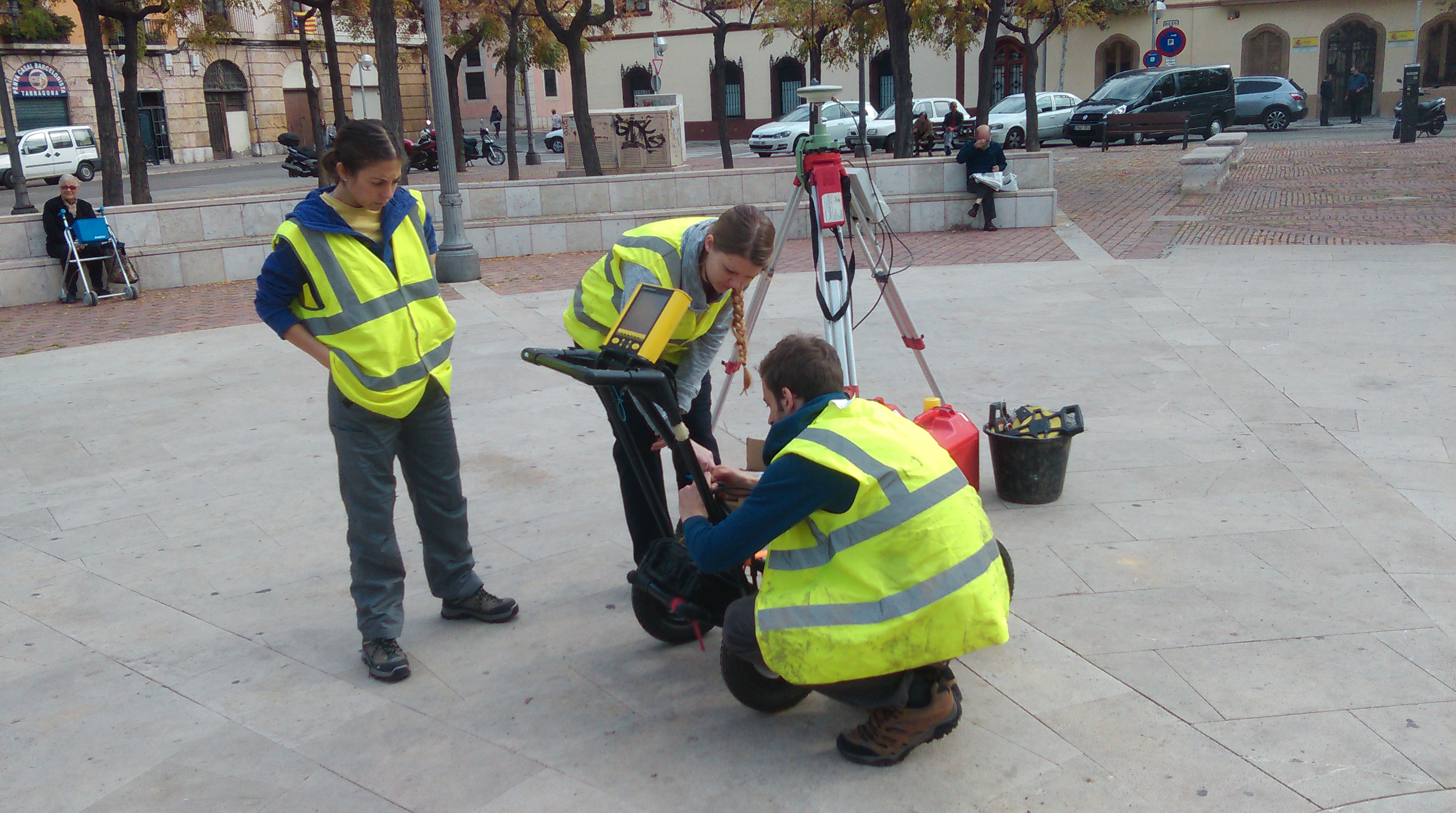
Set up of the GPS and GPR by the University of Southampton team in the Placa dels Carros
The GPS base station collecting static data for the survey
Fortunately for the University of Southampton team, the open plazas of the town provided sufficient space for static data to be collected by the GPS base station, and for a series of preliminary stations to be established using the GPS. Where the streets became narrow a total station was used to establish further stations in a traverse around the port area of the town.
Geophysical survey s far has focused on 500MHz GPR, propagating 3-4m below the modern street level to find the buried archaeology. In some of the streets in the northern part of the port area, particularly along the roads close to the Roman baths and theatre a number of walls and other features are visible. As the survey progresses southwards, however, modern infrasructure such as manhole covers, and the nature of the made-up ground close to the modern harbour, make the results more difficult to interpret. The restrictions in terms of spatial coverage have also provided a challenge in terms of data interpretation.
Total station survey in one of the streets of Tarragona
500MHz GPR survey in one of the plazas
To better understand the geoarchaeology of the site we have been applying Electrical Resistivity Tomography (ERT) to record both archaeology and deeper deposits in the town. The main constraint with this is that the paved areas of the town preclude the use of survey probes (these cannot be dug through cement and Tarmac). Thus we have had to adapt using a system of electrode copper conductors and a conductive gel. Most surfaces will allow an electrical current to be passed through them, but asphalt and Tarmac act as insulators, meaning that for the ERT to work long stretches of cement pavement need to be surveyed.
A conductor formed from crocodile clips, wire and pipe end copper usually used for plumbing.
The ERT profile being conducted adjacent to the Roman theatre
In spite of our initial misgivings, the conductors and gel, with the ERT equipment, have proved to work very well indeed. The profile alongside the Roman theatre has revealed a number of areas of walls and rubble aligned adjacent to the excavated theatre remains. The team hope to conduct a long profile of ERT in the southern part of the modern port which, together with the boreholes of Ferreol Salomon, will investigate the nature of the harbour deposits.
The survey work is being conducted until 15th November, and there are many features of the topography of the ancient harbour that remain to be discovered, including the line of the Roman seafront and mole.
The bay to the east of the port
The post The Portuslimen Project. Geophysical survey at Tarragona, and the constraints of modern urban areas appeared first on Shipwrecks and Submerged Worlds.
]]>The post The Portuslimen Project. Geophysical survey at Tarragona, and the constraints of modern urban areas appeared first on Shipwrecks and Submerged Worlds.
]]>

The modern port of Tarragona, with its harbour, docks and factories
The issue with Tarragona is that the development of the town and port spans from the pre-Roman period, to the establishment of the Roman town in the third century BC, to Late Roman and Visigothic settlement in the 6th, 7th and 8th centuries, and later Islamic influence. Over this time the town and its port expanded and contracted, and archaeological deposits were buried under fluvial deposits from the Francolí river to the west of the port. Later post-medieval expansion of the town, particularly in the 19th and 20th centuries saw much of the Roman and later port built over, and a new harbour constructed over the remains of the ancient port. The aim of our survey is to attempt to locate significant structural remins of the Roman port and harbour through intrusive methods. The good news is that a number of areas in the city have been excavated in the past 40 years, which helps in the location of the survey to gain as much as possible from the efforts. The bad news is that, due to the modern town plan, many of the survey areas are constrained by modern buildings and infrastructure. Thus our work has to use some specific techniques to conduct survey in the areas that are available. This includes topographic survey and location of survey grids using RTK GPS and total station survey, and use of GPR and ERT along streets and in plazas to map buried remains.
Set up of the GPS and GPR by the University of Southampton team in the Placa dels Carros

The GPS base station collecting static data for the survey
Fortunately for the University of Southampton team, the open plazas of the town provided sufficient space for static data to be collected by the GPS base station, and for a series of preliminary stations to be established using the GPS. Where the streets became narrow a total station was used to establish further stations in a traverse around the port area of the town.
Geophysical survey s far has focused on 500MHz GPR, propagating 3-4m below the modern street level to find the buried archaeology. In some of the streets in the northern part of the port area, particularly along the roads close to the Roman baths and theatre a number of walls and other features are visible. As the survey progresses southwards, however, modern infrasructure such as manhole covers, and the nature of the made-up ground close to the modern harbour, make the results more difficult to interpret. The restrictions in terms of spatial coverage have also provided a challenge in terms of data interpretation.

Total station survey in one of the streets of Tarragona

500MHz GPR survey in one of the plazas
To better understand the geoarchaeology of the site we have been applying Electrical Resistivity Tomography (ERT) to record both archaeology and deeper deposits in the town. The main constraint with this is that the paved areas of the town preclude the use of survey probes (these cannot be dug through cement and Tarmac). Thus we have had to adapt using a system of electrode copper conductors and a conductive gel. Most surfaces will allow an electrical current to be passed through them, but asphalt and Tarmac act as insulators, meaning that for the ERT to work long stretches of cement pavement need to be surveyed.

A conductor formed from crocodile clips, wire and pipe end copper usually used for plumbing.

The ERT profile being conducted adjacent to the Roman theatre
In spite of our initial misgivings, the conductors and gel, with the ERT equipment, have proved to work very well indeed. The profile alongside the Roman theatre has revealed a number of areas of walls and rubble aligned adjacent to the excavated theatre remains. The team hope to conduct a long profile of ERT in the southern part of the modern port which, together with the boreholes of Ferreol Salomon, will investigate the nature of the harbour deposits.
The survey work is being conducted until 15th November, and there are many features of the topography of the ancient harbour that remain to be discovered, including the line of the Roman seafront and mole.

The bay to the east of the port

![]()
The post The Portuslimen Project. Geophysical survey at Tarragona, and the constraints of modern urban areas appeared first on Shipwrecks and Submerged Worlds.
]]>The post The Portuslimen Project. Geophysical survey at Tarragona, and the constraints of modern urban areas appeared first on Shipwrecks and Submerged Worlds.
]]>
The modern port of Tarragona, with its harbour, docks and factories
The issue with Tarragona is that the development of the town and port spans from the pre-Roman period, to the establishment of the Roman town in the third century BC, to Late Roman and Visigothic settlement in the 6th, 7th and 8th centuries, and later Islamic influence. Over this time the town and its port expanded and contracted, and archaeological deposits were buried under fluvial deposits from the Francolí river to the west of the port. Later post-medieval expansion of the town, particularly in the 19th and 20th centuries saw much of the Roman and later port built over, and a new harbour constructed over the remains of the ancient port. The aim of our survey is to attempt to locate significant structural remins of the Roman port and harbour through intrusive methods. The good news is that a number of areas in the city have been excavated in the past 40 years, which helps in the location of the survey to gain as much as possible from the efforts. The bad news is that, due to the modern town plan, many of the survey areas are constrained by modern buildings and infrastructure. Thus our work has to use some specific techniques to conduct survey in the areas that are available. This includes topographic survey and location of survey grids using RTK GPS and total station survey, and use of GPR and ERT along streets and in plazas to map buried remains.
Set up of the GPS and GPR by the University of Southampton team in the Placa dels Carros
The GPS base station collecting static data for the survey
Fortunately for the University of Southampton team, the open plazas of the town provided sufficient space for static data to be collected by the GPS base station, and for a series of preliminary stations to be established using the GPS. Where the streets became narrow a total station was used to establish further stations in a traverse around the port area of the town.
Geophysical survey s far has focused on 500MHz GPR, propagating 3-4m below the modern street level to find the buried archaeology. In some of the streets in the northern part of the port area, particularly along the roads close to the Roman baths and theatre a number of walls and other features are visible. As the survey progresses southwards, however, modern infrasructure such as manhole covers, and the nature of the made-up ground close to the modern harbour, make the results more difficult to interpret. The restrictions in terms of spatial coverage have also provided a challenge in terms of data interpretation.
Total station survey in one of the streets of Tarragona
500MHz GPR survey in one of the plazas
To better understand the geoarchaeology of the site we have been applying Electrical Resistivity Tomography (ERT) to record both archaeology and deeper deposits in the town. The main constraint with this is that the paved areas of the town preclude the use of survey probes (these cannot be dug through cement and Tarmac). Thus we have had to adapt using a system of electrode copper conductors and a conductive gel. Most surfaces will allow an electrical current to be passed through them, but asphalt and Tarmac act as insulators, meaning that for the ERT to work long stretches of cement pavement need to be surveyed.
A conductor formed from crocodile clips, wire and pipe end copper usually used for plumbing.
The ERT profile being conducted adjacent to the Roman theatre
In spite of our initial misgivings, the conductors and gel, with the ERT equipment, have proved to work very well indeed. The profile alongside the Roman theatre has revealed a number of areas of walls and rubble aligned adjacent to the excavated theatre remains. The team hope to conduct a long profile of ERT in the southern part of the modern port which, together with the boreholes of Ferreol Salomon, will investigate the nature of the harbour deposits.
The survey work is being conducted until 15th November, and there are many features of the topography of the ancient harbour that remain to be discovered, including the line of the Roman seafront and mole.
The bay to the east of the port
![]()
The post The Portuslimen Project. Geophysical survey at Tarragona, and the constraints of modern urban areas appeared first on Shipwrecks and Submerged Worlds.
]]>