[Advanced] Analyse some palaeo-environmental core data – comments
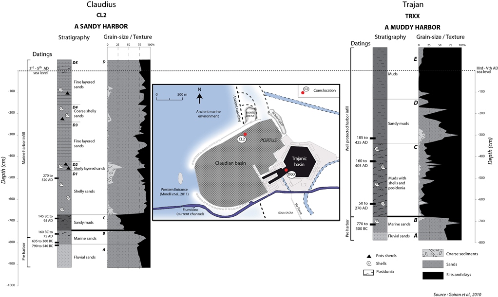
Thanks for all your interesting comments on my [Advanced] step. Lots of hypotheses have been proposed! You all described very well the core sequences. Congratulation! Different sedimentary behaviors can be observed: Claudius’ basin shows sand accretion, whereas the access channel to Trajan’s basin shows mud accumulation.
| MAIN DATASET PROVIDED | Claudian basin | Trajanic basin |
| Grain-size analysis=Hydrodynamism | Sandy | Muddy (silt and clay + organic matter) |
| Water currents passing by the CL2 core location cannot transport coarse sediment (>2mm) and take away silts and clays (<63μm). Only the sandy sediment are deposited (63μ to 2mm)à Medium hydrodynamism | Currents passing by the TRXX core location cannot transport coarse and sandy sediments. Only fine sediment are transported and deposited.à Sheltered environment(possibility of flocculation in a mixed environment between fresh- and saltwater) | |
| Bioindicators (shells, posidonia – seagrass)=Type of environments | Shells | Shells + posidonia |
| (1) Identified shells are generally marine and sometimes from a brackish environment (data where not provided in the graphs)(2) Posidonia (seagrass) is absent probably because of currents that take them away. | (1) Identified shells are mostly from a brackish environment;(2) Posidonia fibers (sea grass) are not in context but transported from another place and settle in the sheltered environment of the Trajanic basin. Nevertheless, it shows an influence of marine currents. | |
| Datings(Radiocarbon dating, ceramics)=Absolute chronology | -7 m = 145BC – 95AD-5 m = 270-520 AD | -6m = 50-250AD-4.50m = 160-405 AD-3m = 185-425 AD |
| Radiocarbon datings provide us a large margin of error. However, these datings suggest that the harbour basins where maintained at an adequate depth to allow Ancient biggest ship to use these harbour basins until at least the 3rd c AD and most probably later. These 2 coring do not allow us to identify dredging phases. | ||
| OTHER QUESTIONS | Claudian basin | Trajanic basin |
| Harbour basins depth (bellow roman sea level of the 3rd -5th c AD recorded at Portus) | 7.50 m | 6.80 m |
| The basins are very deep! For comparison, the biggest ships during Ancient times have a maximum draught of 4.50m. Question still in discussion amongst researchers: why excavating such a deep harbour basins? In order to reduce the frequency of dredging? | ||
| Specific units | CL2 – Unit C = A muddy layer in a sandy harbour basin | TRXX – Unit D = A sandy layer in a muddy harbour basin |
| – Deposited after the beginning of the work at Portus. During the excavation of the Claudian basin or just after?– Was the Claudius efficient as a sheltered basin at the beginning? | – Stronger currents penetrating in a sheltered environment. Two hypothesis: from the river? From the sea?– Complementary sedimentological and geochemical analysis suggest that it corresponds to river inputs | |
| Origin of the sediments, transport and deposition | On a river delta, sediments come from the river (very coarse and very fine sediments). After the river mouth, fine sediment are transported in offshore. Coarse sediments are deposited near the River mouth. Sand are sorted, transported and deposited by the longshore drift (swells) along the coast. > Sand deposits of the Claudian harbour are transported, deposited and sorted by the swells. | On the coast, swells cannot transport very coarse sediment, and silts – clay are not deposited. The Trajanic basin is a quiet environment and traps the fine sediments coming from the Tiber river (mostly during floods). Slow currents lead to the decantation of small particles and cannot transport sands and coarser sediments into the Trajanic basin. Flocculation occurs as well. |
In italics = interpretations
I am proposing you to put into context these results. The main question concerning the harbour basins of Portus is: why Trajan decided to excavate a second basin?
Some hypotheses developed suggested that the Claudian harbour was prone to rapid silting. The results show that Trajan built the second hexagonal basin because Claudius’ harbour did not protect the ships from the wind and swell, and not because of a rapid silting. Tacitus (Annals, 15, 18) tells us about about a strom entering in 62 AD in the harbour basin of Claudius and sank c. 200 ships. This event suggests that the Claudian basin was not sheltered against strong storms and can be related to the result obtained by coring analysis.


