Recent discoveries at Ostia
The Archaeology of Portus MOOC will include some of our very latest findings, recently showcased in international media e.g. on BBC News in the UK. The recent discovery of the walled area of warehouses on the north side of the Tiber at Ostia by the Portus Project and the Soprintendenza Speciale per i Beni Archeologici di Roma represents another major advance in our understanding of the relationship between Portus and Ostia. Both ports were separated by from each other by the Isola Sacra, an island that was bounded by the Tyrrhenian sea to the west, the Tiber to the east and south, and one of the Portus canals to the north, and which is well known for its early Imperial cemetery. Back in 2009, the Portus Project discovered a major canal that ran from Portus in the north to Ostia in the south. In addition the Soprintendenza Speciale per i Beni Archeologici di Roma recently found and excavated two Roman boats near to the point where the canal flowed into the Tyrrhenian sea. Clearly, therefore, there is a growing body of evidence that the Isola Sacra was a key focus of communication between the two ports and helps us to understand the function of both.
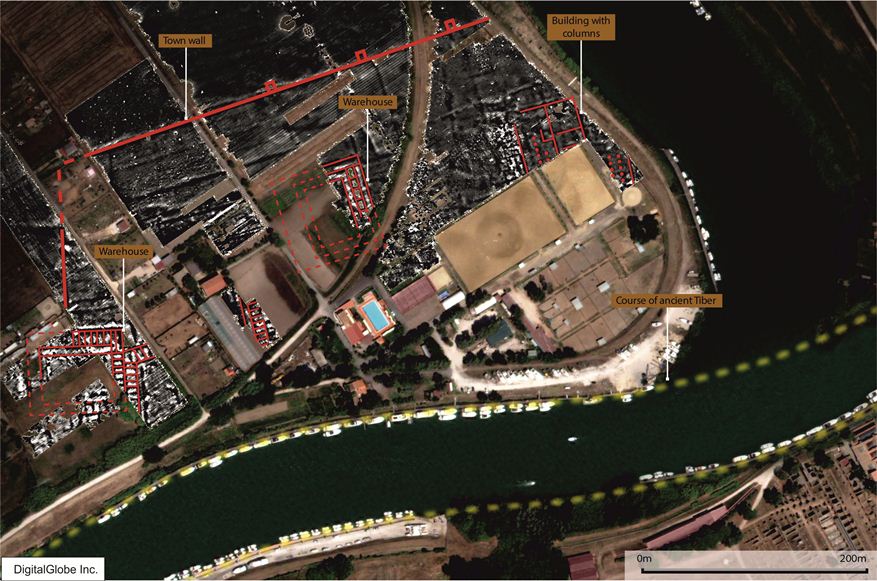
The recent archaeological survey work has uncovered evidence that shows that Roman Ostia was much larger than previous suspected. The missing town wall of Roman Ostia is now revealed together with large towers, warehouses and other structures. Since 2007, an Italian and British team has been undertaking geophysical survey work in land lying between the ancient ports of Portus and Ostia, a few kilometers to the south of the Rome’s International airport of Leonardo da Vinci.
Local archaeological authorities, represented by Angelo Pellegrino and Paola Germoni (Soprintendenza Speciale per i Beni Archeologici di Roma) were committed bringing to fruition the scientific and technical objectives of this research alongside Professors Simon Keay (University of Southampton/British School at Rome) and Martin Millett (University of Cambridge) who, as part of the Portus Project (www.portusproject.org), led a team of archaeologists and geophysicists in conjunction with colleagues at the British School at Rome.
They have been using an established technique known as magnetometry. This consists of systematically and rapidly scanning the landscape with small handheld instruments in order to identify localized magnetic anomalies relating to buried ancient walls, roads and other structures. These are subsequently mapped out with specialized computer software, providing images not dissimilar to aerial photographs that can then be interpreted by archaeologists.
In antiquity, the landscape under study was known as the Isola Sacra, and was bounded by a major canal associated with Portus to the north, the river Tiber to the east and the south, and the Tyrrhenian sea to the west. At the southernmost side of the Isola Sacra to the north of the Tiber, the geophysical survey revealed very clear evidence for the town wall of Roman Ostia running for some 540m from east to west, and then turning southwards in the direction of the Tiber; the wall was interspersed by large towers that measured 6x8m. Between the wall and the river Tiber, an area known to archaeologists as the Trastevere Ostiense, the team found very clear evidence for at least four major buildings. Three of these seem to have been warehouses that are similar in layout to those that have been excavated at Ostia itself, on the south side of the Tiber. However they seem to be much bigger, with the largest measuring c. 83x75m; this is a scale that invites comparison with some of the major monuments at Ostia itself, notably the Piazzale delle Corporazione (110m x 80m), the forum (c. 135m x 30m) and the Grandi Horrea (85m x 125m). These complement the discovery of the remains of a warehouse discovered by the Italian archaeologist Fausto Zevi in this general area during the late 1960s and published in 1971. In addition to this there is a massive (c. 142m x 110m) fourth building composed of rows of columns running from north to south, but whose function is unknown.
These results are of major importance for our understanding of Roman Ostia because they show first of all that the last 1st BC walls that are known to have surrounded Ostia to the south of the Tiber, continued to the north of the Tiber as well. Not only does this increase the known area of the ancient city, but it also shows that the Tiber bisected Ostia, rather than defining on its northern side. Furthermore the presence of the warehouses along the northern side of the Tiber provides us with new evidence for immense scale of the commercial activities that took place on the banks of the river in the first two centuries, increasing the known extent of warehousing at Ostia by about 50% to c. 70,000 square metres. All of these discoveries will lead to a major re-think of the topography of one of the most iconic Roman cities in the Mediterranean.
The physical identification of part of the urban fabric of Ostia in the south of the Isola Sacra has been possible thanks to those Italian laws and rules for the protection of the archaeological heritage that have been enforced by the Soprintendenza speciale per i beni archeologici of Rome since 1960, with the work of Anton Luigi Pietrogrande. Protective legislation and on-site management has preserved and protected an extent of land that is now recognized as an area of early settlement intimately connected to Ostia.


